In March this year firefighters and scientists in Western Australia encountered the latest example of a wildfire that was so powerful it could generate its own weather-system. At the most extreme end of the scale, this can lead to firenadoes (fire tornadoes, first witnessed in Canberra in 2003, reaching 10,000 metres high) or black hail (formed when rapidly rising ash and soot is condensed into ice-crystals).
More usually the rapid updrafts from a fire rampaging out of control create a smoke plume that shoots up until it reaches a point where lower atmospheric pressure exerts a cooling effect and turns it into a cloud. It’s known formally as a flammagenitus cloud, and slightly less formally as a pyrocumulonimbus (pyroCb), but whatever you call it, it’s bad news. For this weather system is in its turn capable of producing winds that can flatten trees and rip off roofs, or of generating ‘dry lightning’ that often goes on to light fresh fires several miles away.
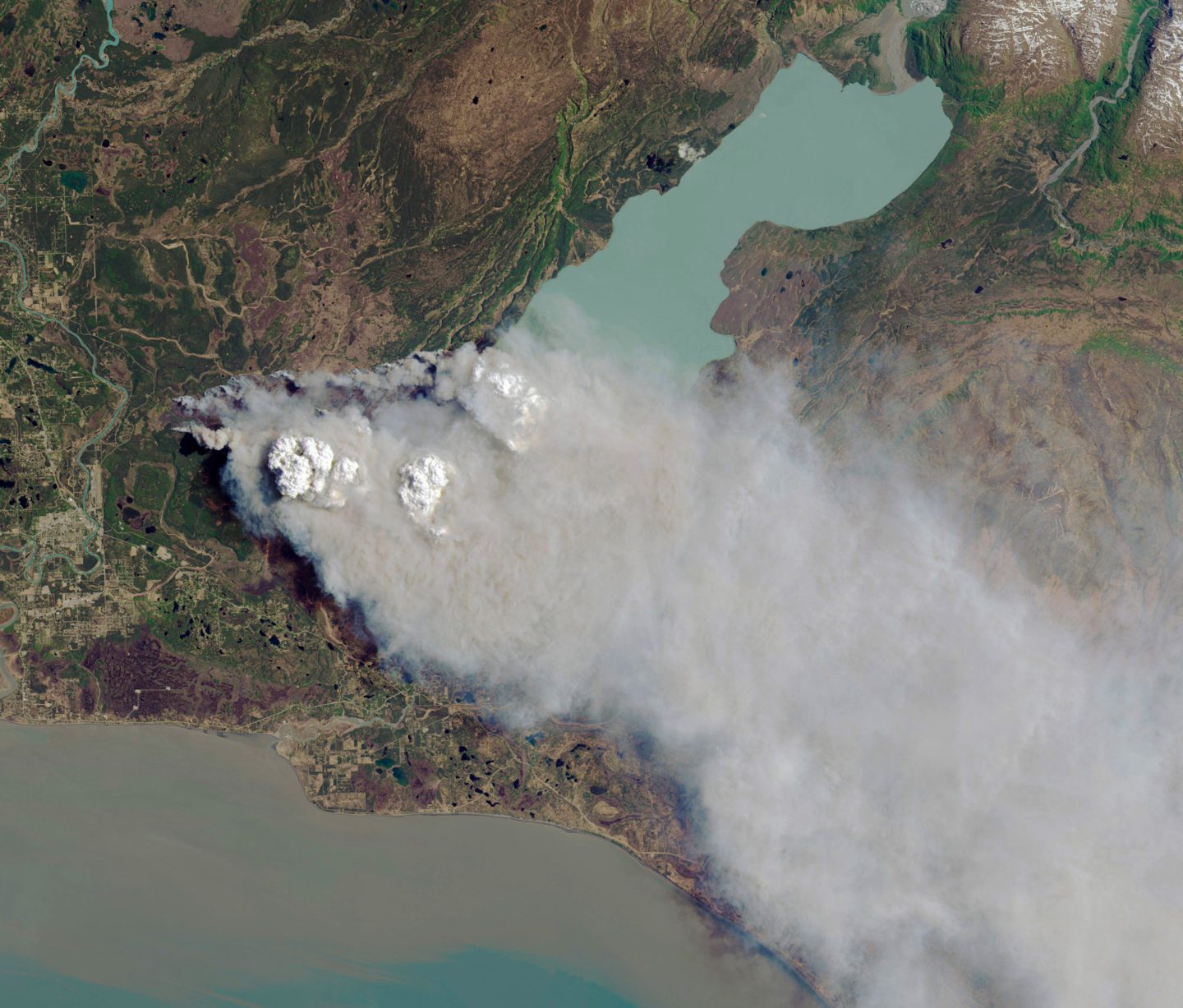
The Funny River Fire, Kenai Peninsula, Alaska, 20 May 2014. Above the blaze are two pyrocumulonimbus clouds – thunderclouds formed when superheated air rises above an intense fire. Photography: Science History Images/Alamy
Mike Fromm, of the Washington-based Naval Research Lab, is one of the world’s leading experts on how these ‘dirty thunderstorms’, as well as reaking havoc on the ground, have a direct impact on climate change. Until the Nineties it was often assumed that volcanic eruptions were mostly responsible for transmitting smoke and related emissions into the stratosphere. Then Fromm, consulting with other scientists, began to realise that many of the anvil-shaped clouds associated with volcanic eruptions were in fact being produced by wildfires, leading to a chain-reaction in which pollutants from the fire were belched 10 miles above the earth’s surface. The cumulative impact of these vertical forces has long term and negative consequences for climate change. When I’m researching this article, Fromm is initially described to me as a ‘fire-chaser’, though when I contact him by email he clarifies with a smiley that ‘I “chase” these firestorms from space, ie through monitoring the earth from satellites’. Does he think these storms are a growing phenomenon?
‘Our science on the pyroCb is not mature enough to make any claims as to trends,’ he replies. ‘What we can say is that over the last half decade or so, there have been 30-60 of these storms per year. We monitor global satellite data in nearly real time and can see these storms start to explode. When that happens we notify a global group of scientists and other interested individuals. A small number of those then physically go out in search of blowups and make measurements.’
‘As humans we tend to think that because we experience something we understand it. And that’s not generally true.’
Mark Finney, Missoula Fire Sciences Laboratory
Analysing wildfires from space is just one aspect of the extraordinary and fast-expanding world of wildfire science, or pyrogeography. This is a world in which scientists fly planes through smoke plumes to measure emissions, create images using heli-kites (a cross between a helium balloon and a kite), or spend day in day out investigating the different species of fire in laboratories. It brings together a whole range of disciplines from climate science to mechanical engineering, economics to behavioural science, and ecology to anthropology. With wildfires becoming increasingly unpredictable from year to year (2018 saw wildfires unusually breaking out north of the Arctic Circle while California endured the single largest fire ever recorded), the need to understand them is intensifying. Just this January, it was announced that a new wildfire research centre, headed up by Imperial College London, will be launched with £10m from the Leverhulme Trust, in order to improve the prediction and management of wildfires around the world.
So what do we actually understand about fire right now? ‘One of the problems we have in general as humans is that we tend to think that because we experience something we understand it. And that’s not generally true.’ Expert Mark Finney works at the Missoula Fire Sciences Laboratory, an American research centre in the Rocky Mountains. It’s a place where scientists use equipment including giant combustion chambers, fire-whirl generators, and wind tunnels to observe everything from the gases produced by fire to the complexities of flame structure. Most experts working in this field see it as the godfather in terms of the authority it wields, not least in peer-reviewing research papers. In the fascinating short online documentary about the facility, The Fire Lab, Finney continues, ‘With fire almost everything is counterintuitive’.
Though it may be an overstatement to say everything is counterintuitive, there’s plenty being revealed by scientific research that’s unexpected. I first discover this when interviewing Dr Thomas Smith at LSE on the only day this winter when London’s covered in snow. In his office, where the clutter includes an orange fire-resistant jacket slung over one of the chairs, Smith deftly demonstrates why his area of expertise should be compelling not just to fellow scientists but to society at large. He starts by showing me a NASA video on which the patches of red indicate fires burning across the globe.
‘When I first introduce pyrogeography to people, I point out that wildfire is a global phenomenon,’ he says. ‘People normally associate it with specific areas on the planet like California or New South Wales, or Greece. These are the places that make the news, because humans have been affected. But in fact fires are taking place continually – across Siberia, for example, in the boreal forest [the coniferous forest also known as the taiga that predominates in snow-covered regions of the globe]. The fire is part of the ecosystem – there are trees that can only reproduce after their waxy cones have been melted by the flames. It looks like the forest has been destroyed, but the seeds go into the ash and grow.’
He explains that we as Europeans have a problem in only perceiving wildfire as a negative phenomenon. ‘A lot of indigenous cultures across the planet use fire as a tool,’ he explains. ‘The savannas, for instance, look natural partly because they’ve been there for thousands of years, but they’re only semi-natural because they’ve been managed by fire. In somewhere like Australia before the Europeans arrived, small fires were frequently started to scorch the bark and burn away the vegetation as it grew up around the trees. Without these fires, the vegetation builds up and builds up, so when a fire eventually happens, it destroys everything.’
So where do we start, when we’re trying to redefine our perceptions of fire? ‘You have to think of fire like an organism, like a species of tree, or a mammal,’ Smith replies. ‘With any species on our planet, there are three things that describe where it occurs: you need resources, which might be nutrients, or prey; you need physiologically appropriate conditions in terms of the climate; and you need some way for that species to be able to disperse. With fire, the resources are the fuel, the physiological conditions are about whether the weather is too wet or not, and the dispersibility is the occurrence of ignitions. The rain forest is one of the most productive places on the planet in terms of fuel, but it’s moist – the least productive place is the desert. Normally fires prefer something in the middle.’
The sense of exactly how important it is to understand every aspect both of what causes a fire and its consequences is most tangible when I go to meet Apostolos Voulgarakis one Friday afternoon in his office at Imperial College London. The charismatic Voulgarakis is a senior lecturer in climate change – before this he worked as a research scientist at NASA. Once I’ve tracked down his modestly-sized office in the Imperial College warren, I find it filled with students discussing techniques for measuring the composition of the environment with pin-drop attention to detail. After they’ve dispersed, he talks to me about how it became realised that understanding fire was key to the broader question of analysing climate change.
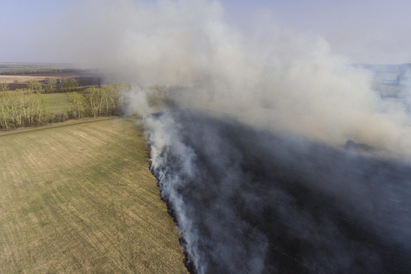
Grass on fire in a field in the Iskitim District of Novosibirsk, in Russia's Western Siberia, May 2017; the administration of Russia's Siberian Federal District declared a state of emergency. Photography: Kirill Kukhmar/TASS/Alamy.
‘When Mike Fromm brought the pyrocumulonimbus to people’s attention through a paper in the Bulletin of the American Meteorological Society, in 2010,’ he says, ‘we got together with him and asked, “what happens if we try and model the impact of those events on the atmosphere?” In particular we studied the 2009 Black Saturday event that took place in Australia and killed 180 people. We knew this generated pyroconvection [the process that creates the pyrocumulonimbus], and discovered that we could model this quite well. So the next interesting question became what happens when there are several of these events in a year? Do they produce a strong enough signal to substantially affect the composition of the stratosphere? Or to put it more broadly, are fires changing our weather?’
Voulgarakis will be heading up the new Leverhulme Centre for Wildfires, Environment and Society in collaboration with experts from King’s College London, the University of Reading and Royal Holloway University of London. He explains how, ‘I realised that we had wide collection of expertise on wildfire in diverse departments that often don’t interact. So for instance at Imperial we have Dr Guillermo Rein in Mechanical Engineering, who’s the great UK expert on combustion and how things burn. We have Professor Colin Prentice who’s an expert on eco-systems, climate and fire. There are economists like Dr Yiannis Kountoris who’s looking at the welfare and cost impacts of wildfire. At King’s there are people who are, for example, investigating the interface between environmental science and social science.’ He smiles. ‘We wanted to create a hub, a “go-to” place for studying wildfire. It will be a new kind of science. It won’t be the engineer who studies wildfire, or the computer-scientist. It will be a wildfire scientist who will have received training in all those areas through being at our centre.’
Both Smith and Voulgarakis emphasise how developments in equipment – along with a proper understanding of how to use it – are revolutionising the way we can talk about wildfire. Smith, for example, has worked extensively with spectrometers – instruments that separate and measure different components of a physical phenomenon, in this case, air composition. A key distinction between different types of fire is whether they demonstrate ‘complete’ combustion (which occurs when there is a good supply of air, and produces CO2 and water), or ‘incomplete’ combustion (which produces gases including carbon monoxide, carbon and methane). It’s generally understood that the latter is the most harmful for the environment, but the more sophisticated spectrometers become, the more they can reveal more complex differences. ‘If you look at diagrams that show all the different chemical pathways in combustion it’s really crazy,’ Smith declares. ‘We still don’t have a full understanding of it.’
‘There are points when I’m talking to the different experts when the life of a pyrogeographer can sound more like that of James Bond than that of an academic.’
Smith’s former PhD supervisor at King’s, Professor Martin Wooster, is one of the most influential and innovative figures in the development of instrumentation for analysing wildfires. A former volcanologist, his specialism is the observation of fire from space – most recently he has headed up a group that has developed the impressive sounding Fire Radiative Power product from the Meteostat Second Generation Satellites. So what does that actually mean? ‘What we call a product,’ he replies sitting in the vegan canteen at King’s, where we are both sipping almond-milk lattes, ‘is essentially when somebody takes raw satellite data, which shows temperatures or calibrated radiances. But people don’t want the raw data – you have to be an expert to interpret it, and they might just want sea surface temperature, or the greenness of vegetation. Our Fire Radiative Power products mean we take the satellite data, we run algorithms on that to find pixels producing fires, and then calculate how much energy those fires are radiating per second. We can tell the timing of the fires, the location of the fires, and essentially measure their strength.’
He is well aware that one of the main challenges those studying wildfire are facing is that, ‘often you are using technologies that were not designed to look specifically at fire. For instance, if you design a satellite instrument to measure the top temperature of clouds, or ocean temperature, typically it’s going to saturate when it sees a fire because it’s going to be way hotter. So now instrument developers are designing instruments that can actually handle those temperatures. Because they don’t saturate, we can do better things with the data.’
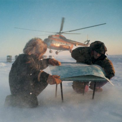
There are points when I’m talking to the different experts when the life of a pyrogeographer can sound more like that of James Bond than that of an academic, not least when doing experiments in the field. ‘We did an aircraft campaign in Canada last year, which was fantastic,’ Wooster continues. ‘It was to validate the Sentinel-3 satellite [developed by the European Space Agency as part of the Copernicus programme that surveys the environmental health of the earth]. Basically we went to a place in Northern Ontario where we could see there were fires. We worked out what time the satellite was coming across, then flew the plane between the satellite and the fire so we could take measurements and compare it to what we get from the satellite.’
Smith, who talks passionately about the problem that laboratory experiments are too often ‘not representative of a real fire burning in a real landscape’, recalls a somewhat hairy experience in Australia when he was measuring gases from an experimental fire. ‘It was in a creek, and the Australians were going to set the fire off at the bottom of the hill by the creek, but they weren’t going to measure the gases till afterwards. I said I wanted to be in the smoke when the fire was happening, so they worked out that they could stick me in a rocky outcrop in the middle of the fire that wouldn’t burn. They helicoptered me and a colleague onto this rocky outcrop. And we watched the fire coming towards us and around us – the roar sounded like a freight train, and the air temperature got up to about 50 degrees. That was definitely one of the craziest experiences I’ve had. I have a video that I show to students, but I have to mute it in several places because of the swearing.’
Uncontrollable fire is making an impact on more and more aspects of modern existence, and an increasing number of organisations are seeking out pyrogeography data. Wooster talks about working with ‘ecologists, air quality scientists, land managers. One good application is with a South African power company called Eskom. If a fire goes under a live high-tension cable you can get sparking, which can damage all the equipment and lead to power surges or certainly uncontrolled shutdowns. So now they use our data to warn the power company there’s a fire within 10km of this particular section of line. They get a text message and the line manager can shut down that part of the line temporarily until the fire’s gone underneath.’
We are in an El Nino year, predicted by some to be the hottest in the earth’s history. It began with an apocalyptic blaze on Saddleworth Moor this February, as well as fires in Australia and in California. At the time of going to press, hundreds were being evacuated from their homes because of fires in southern Norway. The EU’s European Forest Fire Information System was reporting that fires in Europe were ‘way above average’ for the spring season.
It’s all further, and somewhat depressing, evidence that the opening of a new dedicated wildfire centre in London couldn’t be more timely. The race is on to reverse this deadly trend. Of all the factors we can’t understand, what’s in no doubt at all is that over the course of 2019 those satellites watching silently from space will see ever more unpredictable red flares raging across the earth’s surface.